
Counter-UAS Systems for Low-Altitude Security
Build a layered counter-UAS capability with handheld, portable, fixed-site, and vehicle-mounted systems for drone detection, identification, localization, tracking, and RF countermeasure. The portfolio connects GNSS Simulator's navigation-security workflow with deployable anti-drone detection and countermeasure systems for managed low-altitude airspace.
Counter-UAS detection and response systems are intended for authorized security, testing, training, and protected-area management. Deployment and operation must comply with applicable spectrum regulations, aviation rules, local laws, and internal governance requirements. Confirm legal suitability and operating authorization before procurement or use.
One Counter-UAS portfolio, from early warning to authorized response.
Within the broader GNSS Simulator navigation-security portfolio, Counter-UAS represents the operational countermeasure layer. It extends controlled signal testing and resilience validation into deployable systems for low-altitude monitoring, threat assessment, and authorized response.
The portfolio combines passive RF detection, Remote ID reception, direction finding, radar surveillance, electro-optical confirmation, RF link suppression, GNSS navigation-domain countermeasures, and command-and-control capabilities.
Customers can select a standalone portable device or build a connected site architecture using fixed, vehicle-mounted, and integrated systems. Featured systems include P28, P29L, and P37, while additional products and RF modules support broader deployment and integration requirements.
Connect detection, identification, tracking, response, and command in one operational chain.
A Counter-UAS deployment does not always require every layer. Start with the capability needed today, then combine compatible sensors, response devices, and command systems as the protected area and operational requirements expand.
Detect
Passive RF sensors, Remote ID receivers, and radar systems detect drone activity around the protected area.
Identify & Locate
Protocol analysis, Remote ID data, and direction finding help identify supported targets and determine their location or direction.
Track & Confirm
Radar tracking and electro-optical equipment provide continuing target awareness and visual confirmation where required.
Countermeasure
Authorized RF link suppression and GNSS navigation-domain countermeasures provide response options for approved operating scenarios.
Command & Control
The C2 layer connects supported devices, combines incoming data, coordinates authorized actions, and records operational events.
Deploy a single portable detector for temporary monitoring, combine detection and response in one field system, or connect fixed sensors, tracking equipment, response devices, and C2 for continuous protected-site operation.
Compare featured Counter-UAS systems by operational role.
Compare three priority systems across distinct operational roles. P28 combines detection and RF countermeasure functions in one handheld platform, P29L prioritizes lightweight field detection and identification, and P37 provides longer-range RF awareness, trajectory monitoring, and localization information.
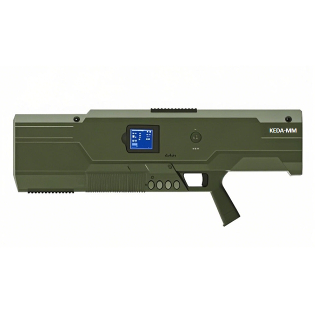
P28
Handheld Drone Detection and Countermeasure Device
A handheld all-in-one system combining spectrum-based drone detection, early warning, identification, direction finding, and multi-band RF countermeasure capabilities in one portable platform.
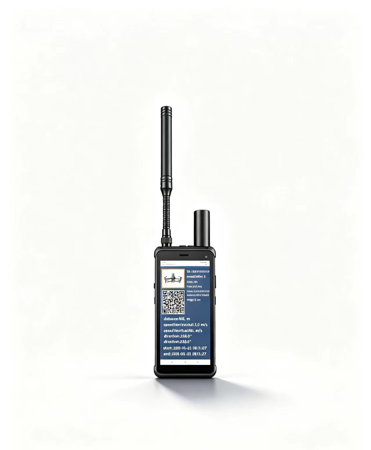
P29L
Portable Drone Detection and Early Warning Device
A lightweight portable detector integrating spectrum sensing, protocol analysis, Remote ID and FPV identification, direction finding, allowlist and denylist management, and electronic geofencing alerts.
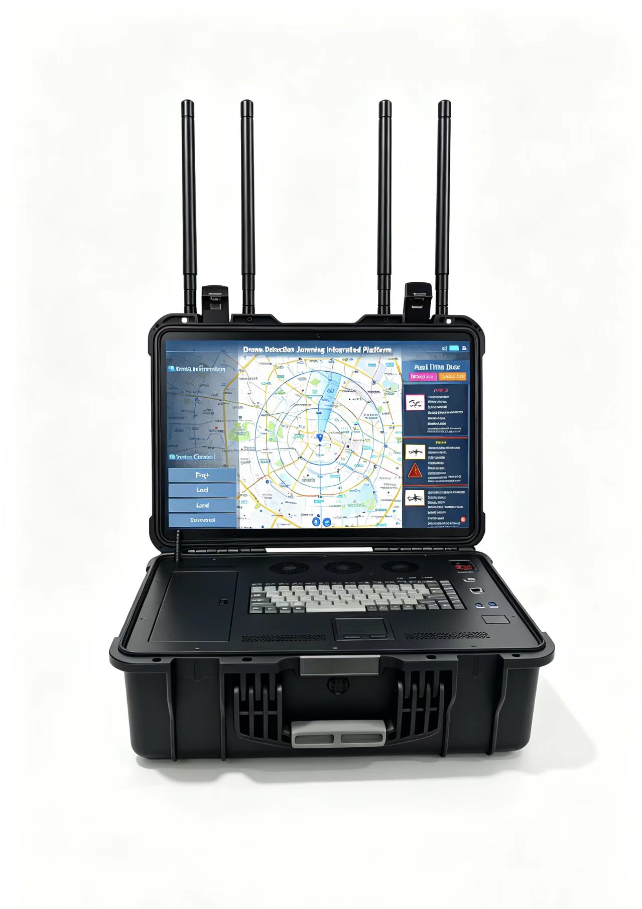
P37
Portable Drone Detection and Localization System
A portable RF detection system for drone identification, multi-target monitoring, flight-path display, and available drone and remote-pilot localization. It also supports Remote ID, allowlist and denylist management, and electronic geofencing alerts.
Detection and countermeasure ranges are reference values. Actual performance varies with the target, signal environment, terrain, antenna conditions, system configuration, and applicable operating restrictions.
Build the required Counter-UAS capability by deployment type.
Start with the featured P28, P29L, and P37 systems, then compare fixed-site sensors, vehicle-mounted systems, portable equipment, integrated platforms, command software, and RF modules for broader Counter-UAS deployment requirements.
C2 Low-Altitude Security Management Platform
A unified management platform for connecting supported RF detectors, Remote ID systems, radar, electro-optical equipment, countermeasure devices, and distributed security sites. C2 combines alarms, identity data, locations, tracks, response status, device health, and historical records in one operating view.
Discuss C2 Integration- Multi-device monitoring and coordinated operation
- Real-time alarms, target tracks, and device status
- Remote task dispatch and cross-site information sharing
- Historical event review and evidence management
Fixed Systems
Fixed-point and site-deployable detection, Remote ID monitoring, positioning, and authorized RF response equipment for protected sites.
Site-Deployable Drone Countermeasure System
A fixed RF response system supporting selective or simultaneous operation across seven configured drone control, video, and navigation-related frequency bands.
Fixed-Site UAV Detection and Positioning System
Combines passive RF spectrum recognition and Remote ID reception with supported UAV and pilot positioning, multi-target tracking, and flight-path display for fixed-point security deployments.
Fixed Remote ID Monitoring System
Receives supported Remote ID broadcasts to provide available drone identity, serial number, position, trajectory, and pilot information with geofence and historical-track functions.
Vehicle-Mounted Systems
Mobile detection, radar, visual confirmation, and authorized response capabilities for patrols and temporary deployments.
Vehicle-Mounted Detection and Countermeasure System
Combines RF detection, identification, positioning, tracking, and authorized countermeasure functions in a mobile vehicle-mounted configuration.
Vehicle-Mounted Electro-Optical System
Visible-light and cooled-infrared imaging for day and night target confirmation, image enhancement, and supported multi-target tracking.
Vehicle-Mounted Phased-Array Radar
Provides continuous 360-degree radar surveillance for small, low-altitude targets and can cue supported electro-optical or connected C2 systems.
Additional Portable Systems
Portable detection and countermeasure options supporting individual operators, mobile teams, and rapid field deployment.
Backpack Drone Countermeasure Systems
Portable backpack response systems for 2.4 GHz and 5.8 GHz drone links. P16 Pro adds supported detection and more selective response capabilities.
Portable Drone Detection and Warning System
Provides real-time detection and warning for supported commercial drones, Remote ID broadcasts, and supported FPV activity in a compact portable format.
Backpack Integrated Detection and Countermeasure System
Combines panoramic RF detection, supported target identification, and coordinated countermeasure functions in one mobile backpack system.
Integrated Systems and RF Modules
Integrated site protection and RF building blocks for complete systems, upgrades, and OEM Counter-UAS projects.
Integrated Counter-UAS System
Combines passive AOA and Remote ID detection with RF suppression and GNSS navigation-domain countermeasures for continuous protected-site operation.
RF Modules for Counter-UAS Integration
RF building blocks for customers developing, integrating, or upgrading Counter-UAS equipment according to frequency, power, switching, and signal-distribution requirements.
Product configuration, supported frequency bands, operating modes, interfaces, and reference ranges vary by model and project. Final capabilities should be confirmed against the target environment, protected area, local regulations, and authorized operating plan.
Compare Counter-UAS systems by capability and deployment.
Select a system according to the required operational role, deployment format, detection capability, and reference range. The portfolio includes standalone detection sensors, dedicated RF countermeasure equipment, and integrated systems that combine detection, identification, positioning, and countermeasure functions.
Choose P28 when a single handheld device must combine drone detection, identification, direction finding, and multi-band RF countermeasure capabilities.
Choose P29L for lightweight field detection, early warning, Remote ID and FPV identification, direction finding, and rapid mobile deployment.
Choose P37 for longer-range RF detection, multi-target monitoring, flight-path tracking, and available drone and remote-pilot location information.
| System | Primary Role | Detection & Awareness | RF Countermeasure | Deployment |
|---|---|---|---|---|
|
Featured
|
Handheld integrated drone detection and countermeasure |
Detection, identification, and direction finding
500 m-3 km |
Integrated multi-band RF countermeasure
500 m-2 km |
Handheld all-in-one system |
|
Featured
|
Lightweight drone detection, identification, and early warning |
Spectrum detection, protocol analysis, RID and FPV
identification, and direction finding
1-2 km |
Not included | 0.62 kg handheld detector |
|
Featured
|
Long-range RF detection, identification, and location awareness |
Drone identity, flight position, trajectory, and available
remote-pilot location
3-5 km digital; 1 km analog; up to 8 km RID |
Not included | Portable box-type detection system |
| Portable multi-band RF countermeasure; Pro version adds drone detection |
P16: no integrated detection
P16 Pro: up to 800 m |
Multi-band RF countermeasure
500 m-2 km |
Backpack countermeasure system | |
| Portable drone detection, identification, and early warning |
Spectrum and RID-based detection across 300 MHz-6 GHz
500 m-3 km |
Not included | Handheld portable detector | |
| Backpack integrated drone detection and countermeasure |
Panoramic detection, identification, and target awareness
500 m-3 km |
Integrated coordinated RF countermeasure
500 m-2 km |
Backpack all-in-one system | |
| Vehicle-mounted integrated detection, positioning, tracking, and countermeasure |
Passive RF detection, drone identification, positioning,
tracking, and available pilot location
1-3 km urban reference |
Integrated RF countermeasure
1-3 km reference |
Vehicle-mounted integrated system | |
| Site-deployable multi-band RF countermeasure | Requires a separate detection or cueing system |
Seven-band RF countermeasure
500 m-2 km |
Site-deployable countermeasure system | |
| Fixed passive RF detection, identification, and positioning |
Passive RF and Remote ID detection, multi-target tracking,
flight paths, and available UAV and pilot positioning
1-5 km urban; up to 8+ km in open areas |
Not included | Fixed-site passive RF and Remote ID system | |
|
P33
|
Networked Remote ID monitoring and flight-record management |
Remote ID reception, drone identity, position, flight data,
and available pilot information
1-2 km per station |
Not included | Fixed networkable RID monitoring sensor |
|
P34
|
Wide-area radar detection, tracking, and target cueing |
Phased-array radar surveillance with 360-degree azimuth
coverage
Up to 5 km |
Not included | Vehicle-mounted phased-array radar |
|
P35
|
Day-and-night electro-optical tracking and visual confirmation |
Visible-light and cooled-infrared imaging for target
observation, tracking, recognition, and confirmation
Range depends on system configuration |
Not included | Vehicle-mounted electro-optical sensor |
Detection and countermeasure distances are reference values rather than guaranteed performance. Actual results depend on the drone model, signal environment, terrain, antenna position, system configuration, and local electromagnetic conditions.
Detection sensors, radar, electro-optical equipment, RF countermeasure systems, and command-and-control software can be combined into a project-specific Counter-UAS architecture. Active RF countermeasure functions must only be deployed where permitted by applicable laws and spectrum regulations.
Need help selecting the right Counter-UAS configuration?
Tell us about the protected area, expected drone types, required detection range, mobility requirements, and permitted countermeasure capabilities. Our engineering team will recommend a suitable standalone system or integrated configuration.
Configure the system around the protected area.
Counter-UAS requirements change with the size of the protected area, expected drone activity, deployment duration, surrounding RF environment, and available operating authority. Select standalone equipment or combine multiple system layers.
Airports and Transportation Hubs
Support fixed-point low-altitude monitoring around runways, terminals, logistics hubs, rail facilities, and other controlled transportation environments.
Fixed RF detection + Remote ID + radar + electro-optical confirmation + C2
Critical Infrastructure
Protect energy facilities, industrial sites, communications assets, data centers, and other restricted infrastructure that requires persistent monitoring.
Public Events and Temporary Security
Establish temporary low-altitude awareness for major events, exhibitions, public gatherings, VIP activities, and temporary protected zones without permanent infrastructure.
Border, Coastal, and Port Security
Support mobile patrols, checkpoints, coastal observation, ports, remote posts, and wide-area security operations where deployment locations may change.
Government and Secure Facilities
Combine fixed-point monitoring, identity information, target location, visual confirmation, event records, and approved response options for controlled facilities.
Mobile and Emergency Deployment
Provide rapidly deployable monitoring and authorized response support when teams must move between locations or establish a temporary security perimeter.
The products shown for each scenario are reference combinations, not fixed packages. Final system architecture depends on site coverage, target types, electromagnetic conditions, integration requirements, and applicable legal authorization.
Common questions before selecting a system.
Selection begins with the required detection capability, expected drone activity, deployment format, protected area, and legally authorized response options.
What is a Counter-UAS system?
A Counter-UAS system detects and assesses unauthorized or potentially unsafe drone activity. Depending on the configuration, it may support identification, direction finding, location, tracking, visual confirmation, Remote ID monitoring, and authorized countermeasure functions.
Which should I choose: P28, P29L, or P37?
Choose P28 when one handheld system must combine detection and an authorized countermeasure option. Choose P29L when low weight, early warning, Remote ID, and FPV identification are the priorities. Choose P37 when the team needs longer-range detection, target trajectories, and available drone and pilot location information.
Can I start with detection only?
Yes. P29L, P29, P31, P33, and P37 support detection, identification, or monitoring roles without an integrated RF countermeasure.fól A compatible response system can be added later when the site requirement and local authorization permit it.
Can the systems detect FPV drones?
Selected products support detection and identification of supported FPV signals. Actual detection depends on signal characteristics, target configuration, distance, and the surrounding RF environment.
Can the systems receive Remote ID data?
Selected systems, including P29L, P29, P33, and P37, support Remote ID reception. Available identity, location, trajectory, and pilot information depends on the target broadcast, supported protocol, and regional implementation.
Can multiple devices connect to one platform?
Yes. The C2 platform can connect supported fixed, portable, and vehicle-mounted devices and combine data from RF detection, Remote ID, radar, electro-optical, and authorized response systems within one operating view.
Why do detection and countermeasure ranges vary?
Range depends on the drone and controller, signal characteristics, terrain, buildings, interference, antenna placement, deployment height, weather, and system configuration. Published distances are reference values, not guaranteed performance in every environment.
Are countermeasure functions legal everywhere?
No. RF suppression, navigation-domain countermeasures, and related functions may be restricted or require specific government authority. Customers must confirm applicable law, licensing, spectrum requirements, and operating approval before deployment or use.
Tell us what you need to protect.
Share the protected area, expected drone activity, required detection range, deployment format, authorized response needs, and integration requirements. Our engineering team will help identify a suitable standalone product or connected system configuration.